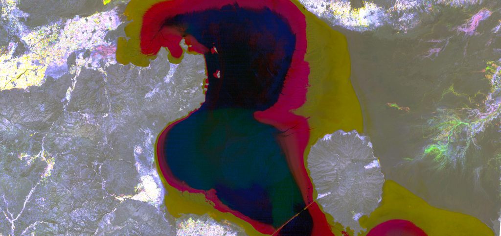
Dr. Gray took home top honors in the graphics/illustration category for faculty and staff in this year’s NC State University Envisioning Research competition. The winning image seen above (“Water Colors”) shows a composite of three Landsat images over Lake Urmia, Iran. Lake levels have fallen dramatically over the past three decades, and SEAL researchers are intent to find out why. In particular, we think that it’s a combination of climate (greater evaporation and less precipitation) and anthropogenic use (irrigation water use). We’re trying to figure out the relative contributions of these forces using remote sensing and hydrologic modeling.
Lake Urmia, Iran was once one of the largest saltwater lake on Earth. Damming of its tributaries and pumping of groundwater to support higher intensity agriculture, along with climate change, have reduced Urmia’s extent to 10% of its former size. This image is a false color composite of three Landsat satellite images from the summers of 1987, 2010, and 2015. Black and dark blue areas show the current extent of the lake, yellow areas depict loss from 1987-2010, and red shows further losses from 2010-2015. The easternmost extent of the image shows an intricate braided pattern of ephemeral streams and vegetation. Yellow and pink hues in the brighter croplands highlight new fields since 2010. We use massive stacks of satellite imagery to map where and how agriculture is changing, and to model the effect of this on water resources. Ultimately, we hope these insights will support a more sustainable future.